![]()
![]()
Égliseneuve-d’Entraigues
Pédestre
Distance : 12 km
Durée : 3h30
Difficulté : Modéré
Tracé : Boucle
Dénivelé : 270 m
Balisage : Yellow
dsio.detail.telecharger
dsio.detail.accesPoint
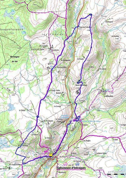
Reach Egliseneuve-d’Entraigues, 64km south-west of Clermont Ferrand. Parking and departure sign at Place de la Poste.
dsio.detail.topo
Étape 1 : From the start sign, turn right after the post office, cross the road to pass the tourist office and take rue du Riou Cros. At the end of the village, turn right onto a small road, then onto a track. Continue uphill for 500 m to a T-junction. Turn right onto the D30. Follow the road to the right for 100 m, then turn left onto a small road to Aulnay. After the last house, fork left onto a track. At the next fork in the road, turn right onto a sunken track as far as a barrier. Go through it and follow a track through the pastureland (view of the Artense plateau and the Sancy massif). At the exit, turn left onto a small road leading to the RD 128.
Étape 2 : Cross the road and take the path opposite. After crossing a stream, continue to a road. Turn right, cross Dressondeix and, at the crossroads, go straight ahead towards Contains. Go straight on, then leave the road at the second turning on the right. At the intersection, take the right-hand path, cross the Clamousse and climb up to the road. Cross the road and climb up a small tarmac road to a building at the top of the hill (view of the Cézallier and Monts du Cantal).
Étape 3 : Turn right, cross a ladder and follow the fence into the meadow. Cross a second ladder and follow a track to the right in the pasture towards an isolated tree, then a third ladder. Cross it and follow the track through the pasture on the edge of a slope (Grosleix stream). Pass a fourth ladder and climb towards a buron. Follow it to the right and continue straight on to a fifth ladder. Cross the ladder, follow a wide track in the meadow and continue on a wide stone track to a small road at Bost de Village.
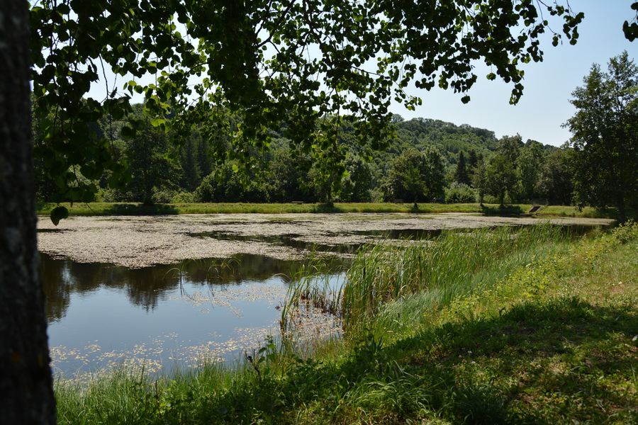
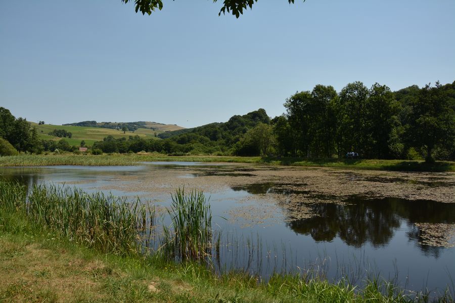
Étape 4 : Turn left onto this road. After 150 m, ignore a road on the left and continue to farm buildings. Continue on a track to the hamlet of La Farge, then on a small road down to the road opposite the lake.
Étape 5 : Follow this road to the left for 100m. Turn right to bypass the lake and follow the dike. At the end of the lake, descend a few steps to the left, cross the road leading to the campsite and take the path opposite leading to the Entraigues waterfall. Cross the stream, then join the D978 (iron cross on stone base). Take the road on the left to reach Egliseneuve-d’Entraigues and the starting point.Proposed and managed by the Conseil départemental du Puy-de-Dôme – PDIPR.
dsio.detail.topo
Opening
From 01/01 to 31/12 daily.
Subject to favorable weather.
dsio.detail.titles.equipements
dsio.detail.complement
Mountain location
For your own safety, always take a bottle of water, a hat, warm clothing and footwear suitable for walking.Depending on weather conditions, certain itineraries are not recommended in bad weather (fog) or are not practicable, or even forbidden, during the winter season.Some sites are fragile, so stay on the marked trails. Avoid picking wild flowers and disturbing wildlife. Pick up your garbage.Animals are not allowed on some routes.
dsio.detail.animaux
Pets allowed on leash only.
dsio.detail.maj29 May 2026